


Deni Suwardhi
Integrated Social Welfare Data (DTKS) is often problematic because the data is not in accordance with the actual conditions in the field. One example of the impact of the inaccurate DTKS is the error in channeling various kinds of social assistance. One system needs to be built in a village that stores DTKS and is based on geospatial, so that the location/house of the community related to DTKS and its accessibility can be easy to use for various purposes. In the system there must be an accurate and high -resolution basic geospatial information so that the surrounding buildings and infrastructure can be seen clearly. If the geospatial is to get an accurate description of the village earth, for example, which is a village boundary, public facilities, springs, agricultural land and disaster -prone areas. Then the spatial social is a data collection on the social conditions of the village. Starting from the population, the number of toddlers, the elderly, the disabled citizens, children who go to school at all levels, the average income of the population to the source of income. The results of geospatial and spatial social mapping can be the basis of the village government to compile its development program plan. The community empowerment program will also be more successful if supported by social, cultural, economic, health, education, data and child data, including the history of the villagers.
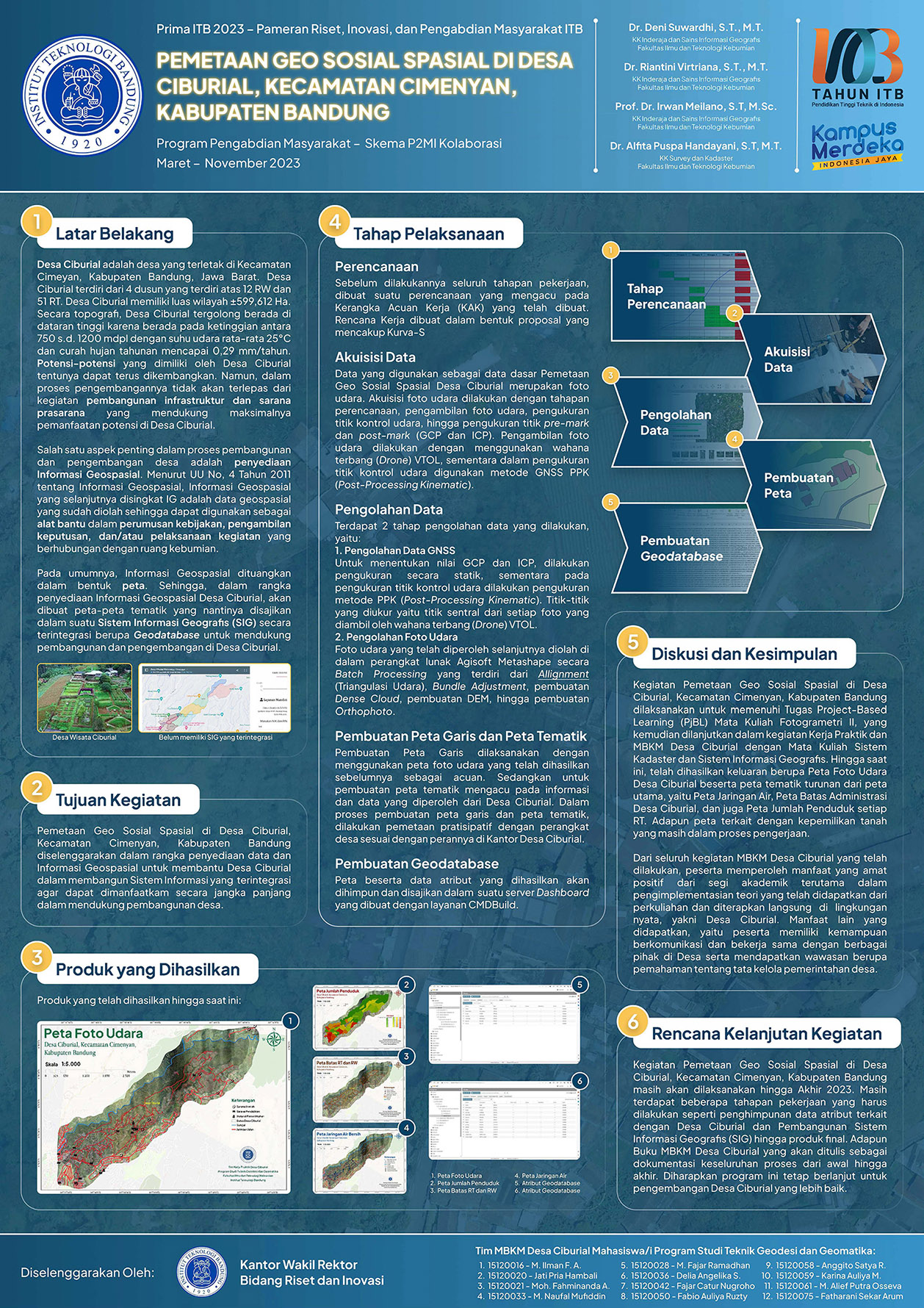
In this community service activity, a village geospatial information system was built based on the very high basic geospatial data obtained from air shooting using drones. To fill in various social information, participatory mapping techniques will be used using mobile / smartphone technology and involving various groups of people and village officials. Ciburial Village, Cimenyan District, Bandung Regency was chosen to be the target of community service this time. The village is a developing village and is close to the ITB Academica Civitas, where many educators and lecturers live in the village. It is expected that the results of this community service can help Ciburial Village in managing the region and its population is even better so that it can become a pilot to implement the concept of one map data from the village.
Increasing the capacity of village government staff to use and develop an independent village information system; Developing a village information system complete with an analysis system that can provide a variety of information related to the village, ranging from information on the location/house of the population to the information related to social, economic and resilience of the village; Creating a basic map of Ciburial Village with Photogrammetry UAV techniques that will be used as basic geospatial data in a complete village information system using geospatial information technology
Ciburial Village benefits from this activity in the form of a base map, in the form of photo maps and maps of village land cover lines that are integrated in a village geospatial information system for the management of residents and village land. Village staff received knowledge and technology transfer from students participating in the Ciburial Village MBKM program related to geospatial technology. Of all the community service activities and the Ciburial Village MBKM program that has been carried out, participants of the activity benefit very positive in terms of academic, especially in implementing theories that have been obtained from lectures and are applied directly in the real environment, namely Ciburial Village. Another benefit gained, namely participants have the ability to communicate and cooperate with various parties in the village and get insights in the form of understanding of village governance.